Carte et géographie de Malte

Looking for the location of Malta on a map? Find out all the geographic points of interest about Malta.
Search for accommodation in Malta
Where is Malta?
Malta can be found in the Mediterranean Sea about 85 km south of Sicily, Italy, 320 km east of Tunisia and 350 km north of Libya.
The country of Malta is made up of three main islands: Malta, Gozo and Comino. The other islands are insignificant and mostly only a few tens of metres in size.
Malta has an area of 316 square kilometres, From west to east the main island measures about 18 km, while from north to south it measures about 25 km.
Online map of Malta
Check out several maps of Malta to easily find out where to stay, where the greatest concentration of attractions or hiking routes are.
Geography
The vast majority of the coastline of all the islands is rocky. The surface consists of various types of permeable limestone, which is often used as building material. Geographically and geologically, Malta belongs to Europe.
The islands of Malta and Gozo are very rugged with hills, valleys and faults.
Malta has a very limited supply of fresh water - according to the UN, it is the most water-poor country in the world. The water supply to the population is nowadays provided by a total of four seawater treatment plants. Parks and agriculture use rainwater and some water from wells. The taps mostly run on desalinated seawater.
The island of Malta
Malta is home to the majority of the population, the national capital and the only airport. There are no rivers or mountains. The surface is gently undulating, with low hills.
The island's landscape is characterised by fields that are terraced on gentle slopes and separated by walls. Malta's very rugged coastline has numerous harbours, rocky coves and sandy beaches.
Gozo
Six kilometres north-west of Malta lies the island of Gozo. The capital of this island, Victoria, is better known as Rabat. Mgarr is the most important port on the island.
The small island of the nymph Calypso, which in ancient times was called Ogyda, is the breadbasket of the Maltese archipelago. It is smaller, greener and quieter (less than a tenth of Malta's population).
The terraced fields, first established by the Arabs more than 1,000 years ago and so typical of Malta, can be found at every turn on Gozo. There is a special peace and tranquillity here. This atmosphere is not only breathed on visitors by the landscape, but is also typical of the inhabitants, who are known for their special character. For those who want to take a break from themselves, Gozo is the ideal place.
Comino
Even quieter is the island of Comino, which is the smallest island in the Maltese archipelago. Only a few peasants live here and no cars or other conveniences disturb the peace.
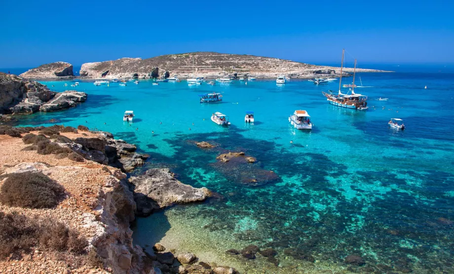
Numerous coves, rocky cliffs and crystal clear azure waters create ideal conditions for all kinds of water sports, but especially for diving.
Comino is connected by boat to both Gozo and Malta. The most famous bay is the Blue Lagoon - azure water like only in the Caribbean. The big minus, however, is that it is a very frequent and busy destination for trips from Malta, so there are a significant number of tourists and boats in the summer.
Malta in numbers
At the end of this chapter, we also present some interesting geographical records of Malta.
- The highest mountain - Ta'Dmejrek (253 m above sea level).
- Longest river - there is no river in Malta
- Neighbouring countries - 0 (Malta has only maritime borders with Italy, Tunisia and Libya)
- Length of coastline - 219 km
Reste-t-il des questions ?
Si vous avez des questions ou des commentaires sur l'article...

